Do you need help travelling to see a show in London? We have a few tips that might help you get around the capital.
What is the West End and where can I find it?
A visit to London is not complete without a trip to the West End. This exciting hub, located in the district of Central London, is where you will find many of the city’s major tourist attractions and shopping areas and of course, is the epicentre of theatrical entertainment.
The West End covers the entirety of Theatreland (except Royal Festival Hall and the Old Vic, which are both south of the river), and includes the surrounding areas of Soho, Covent Garden, Leicester Square, and Aldwych.
From the north it runs across Oxford Street from Oxford Circus to Holborn and connects south to Aldwych, west along the Strand to Trafalgar Square and then north again, rejoining Oxford Circus.
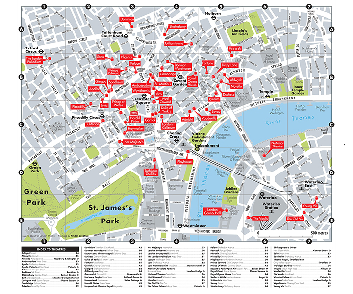
 Map of Theatreland by Andy Robinson.
What are the closest tube stations to Theatreland?
The closest tube stations to Theatreland include Piccadilly Circus, Charing Cross, Covent Garden, Leicester Square and Tottenham Court Road.
Click the image below to download a map that will help you navigate your way around Theatreland.
 Use our poster to find your way around Theatreland.
Where should I park my car in Theatreland?
Book your parking with Q-Park before your theatre visit and get 50% off. Valid seven days a week after 12pm for up to 4 hours, the offer is available at the following participating theatres:
Adelphi | Aldwych | Ambassadors | Arts | Apollo | Apollo Victoria | Cambridge | Criterion | Donmar Warehouse | Drury Lane, Theatre Royal | Duchess | Duke of York’s | Fortune | Garrick | Gielgud | Gillian Lynne | Harold Pinter | Haymarket, Theatre Royal | His Majesty’s | London Coliseum | Lyceum | Lyric | Noel Coward | Novello | Palace | London Palladium | Phoenix | Piccadilly | Playhouse | Prince Edward | Prince of Wales | Savoy | Shaftesbury | Soho | Sondheim | St. Martin’s | Trafalgar | Vaudeville | Victoria Palace | Wyndham’s
Parking is available at one of the following participating Q-Park car parks:
Burlington | Chinatown | Leicester Square | Marble Arch | Oxford Street | Park Lane | Pimlico | Soho
Find full terms and condition’s on Q-Park’s website.
Stay safe in Theatreland
London is a busy city, so we recommend being careful with items such as your mobile phone. Read our simple steps to protect your phones and valuables here.